Thursday 18 February 2016

Arnside Knott loops

I loved New Zealand but I am also really enjoying revisiting places closer to home and appreciating the seasons (well I do when it is cold and bright, perhaps not so much when it is wet and cloudy). Arnside is too far from home to be a really regular haunt but we had an errand in Lancaster and the Rock and Run sale near Milnthorpe so a run would fill most of the gap nicely.
We did not plan to stick together but knew that  with circuits of a fairly small area we were likely to see each other. The sun was out, there was almost no wind and the ground was a bit muddy but not too bad. The limestone sections were  dodgy and I treated them with due caution. I managed 3-4 big loops with almost no repetition of routes or paths.

After a lower loop to the east to get warmed up I headed for the summit cairn and enjoyed the old coppiced woods and the open views. From the top I could see snow on the Lakeland tops but I also liked the view inland to the Pennines and south across the bay. My gloves were soon discarded and I made a detour to leave my extra layer in the car. I was too hot in the thick thermal layer as it was and still had my windproof with me.

Morecambe bay looked interesting in the sunlight and with the tide out. It is some years since I have done one of the cross bay walks so perhaps I should investigate some dates for this year. Having explored to the far western end of the woods and dropped down to the Silverdale road and campsite I jogged along the lane and through the campsite  and onto the shore. the tide was out but I stayed on the stone beach and then the muddy path that contours the small cliffs.

It got even more muddy on the estuary side and I was pleased to turn back up hill and into the woods. I found it hard work uphill and slowed to a walk.

This was the one and only place that I met Bob, although I had not realised that he had left the Knott and gone exploring over by the old fortified tower in the hope of less steep ground.

It was steep but mercifully short and before long I was running through the tress again before breaking onto open ground and charging down the grassy slope to improve my miles per hour stats. By now I was getting some confused looks from dog walkers and families that I had already seen or passed once already.

The area is very varied and I used the big open field area to run in the sunshine and to give myself a break from the steep climbs. After 2 1/2 hours I had had enough and started to make my way back. Contouring on a path above the car I could see it was empty and so did one further loop but I did not want to repeat paths and was content with my 14.5 miles. I got back to the car just after Bob and in time to meet Geoff Pettingell. This was a total surprise as he lives miles away but had been to Milnthorpe for a meeting. The cafe in Arnside was still open so we refuelled with meat pies and gravy.

Saturday 13 February 2016

Back in the UK now

Having arrived back and overcome jet lag plus sorted out a house left in the sole charge of a 23 year old male I decided I better get some running fitness back soon if Haworth Hobble was not going to be even more painful than usual.
I managed to combine a nice easy run on my own under no pressure with a trip around the permanent orienteering course on Beacon Fell. I parked at Brock and set off through all the expensive Landrovers, over the railway line and upstream along the river. It was mild down here with almost no wind. I jogged happily along the river bank admiring the snowdrops and soon arrived at Walmsley Bridge.

From here the ground became more of an issue. It was wet from the recent rain and muddy from the rain of the last few months. I splashed on but wished I had used dry socks as well as normal ones. One thing that I liked in NZ was the lack of dogs. They are not allowed in National Parks or most recreation areas, partly to allow others to enjoy nature without them and partly to protect flightless birds. The first dogs I met today were off their leads and bouncing around exuberantly. The owners shouted repeatedly at them but the dogs just ignored them.They did not bark or growl but they did race around my feet with a real danger of tripping me and I feel I have the right to explore footpaths without this hassle. I said so to the owners. All the other dogs I met were totally under control whether on a lead or not. I have run further up the Brock valley but today I stopped at the mill and turned to Beacon Fell. That I can still find new paths to run on so close to home amazes me. It was a steep pull up through the newly planted trees and much colder up here. The view to the coast was a bit hazy but it was dry and pleasant. I jogged even more slowly round the permanent course checking the posts and making a record of the needle punches en route. The northern woodland is still a joy to run through but some other areas have really suffered from logging and wind damage. The posts were all there and despite some vandalism the punches all worked. I picked a slightly different route back to the mill and then retraced my footsteps. Part of the river path is officially closed but still passable. The floods that affected the Lakes and Pennines had clearly torn away river bank and allowed trees to fall here.
My other attempt to gain running fitness was to enter the Anglezarke Amble. It is always the weekend of Valentines Day and I have missed a few when it was half term and we went skiing but I love this event (it's not a race). It makes a great start to the running calendar and although only 24-25 miles has some good climbs.
So early that I was runner No3
It is home turf so we had a bit of a lie in and only a short drive. It was wonderful to see so many friends again and we had plenty of time to socialise. After two cups of tea and one final loo stop I wandered outside to test the temperature. Yep- cag, gloves and hat for me. The hat would not last long but it was chilly waiting for the final entrants to register and the hall was struggling with the volume. Bob felt his cataract improved eye had settled enough to run and he was doing the slightly shorter variant. Despite the crowds we were still off at about 8am.

 I knew the start would be too fast and a struggle for me and I just let it go and ran when I could. There seemed no point trashing myself at such an early stage and it was really a training run. Andy Ford went on to win in about 3 hr 36, awesome. Josie, Albert and Tony were running well and soon disappeared. I assumed Pete and Dave L were up ahead and I could still see Andy. By the Pike my body had warmed up and was getting more used to the idea of running again. I raced down to the track being careful not to trash my quads. The pull up and over Winter Hill was easier than I thought it would be and I ran most of it spurred on by the chill and a desire to keep Andy in sight. The path leading down to the Belmont -Bolton road is getting even more eroded but I enjoyed the descent and by the fields across the road I had caught Andy. There was no checkpoint at the minor road today and so no bananas. Instead we ploughed on uphill to the top road and the start of the boggy fells. With clear weather there were no navigation issues today and I was overjoyed to see that I had caught Isaline, Dave and Pete. Crossing the main road I ran with Pete for a bit through the mud under the pylons and down to Entwistle reservoir. Again the CP was not where I expected. I grabbled a huge slice of cake and pushed on. It must have been good fuel because that was the last I saw of the Preston Harriers. My legs had now settled down and by not pushing the pace too much they allowed me to run pretty much all the way to Cadshaw and the main road. The sun was now out and I had to pull open my cag and roll the sleeves up. Isaline caught me up and after a chat passed me for a bit. There are two right turns towards the Tower and I took the first. We now know that this is the faster route.

I arrived at Darwen Tower alone and could not find a marshal or a needle-punch. Oh well, on on. I knew now that the worst was over and enjoyed the views of an area I had missed while we were away. The drop down to Slipper Lowe was a pleasant gradient and I knew there would be food. The marshals here were amused that I had spent time looking for one at the Tower (serves me right for not reading this years instructions).

I had a feast here of quiche and cake. By now there were quite a few shorter route walkers and I wondered how Bob was getting on. First though was the not insignificant task of crossing the bog and climbing up Great Hill.

I used walkers to pull me along and was soon at the shelter wall. Pretty much all down hill from here. The path down to Drinkwaters ruin was fairly dry  and the path all the way to the Goyt has been worse in other years. One faster runner caught me here but the others that I had overtaken were not in sight. I dinked in to the cricket ground and decided to have a cup of tea. It is easy to miss this CP through two gates as an out and back and sure enough as I rejoined the path I spotted Isaline. She had missed the gate and was not for going back. can't say I blame her. It was getting a struggle now but only about 3 miles left so man up and get on with it. I used Isaline and walkers to keep me motivated but I did slow to a walk on a couple of deep muddy bits and even along the quarry road for a spell. One last climb up past the reservoir overflow and we were almost back. The last steps and one muddy field and I culd see Isaline would finish a minute ahead of me. Phew. Glad to be back. 4 hrs 40 was not so bad as I had not really run for almost 4 months. Jedburgh was my last race and although  ran Kepler in NZ I was on my own and stopped many times for views and photos. I loved my holiday but it was nice to see our local fells again. (2014 4hrs 38   2013 4hrs 32 so not too bad at all)

Friday 12 February 2016

The Kepler Run

We had thought about doing this as an ultra trail race whist we were in New Zealand. We tried to beg an early entry and were told sorry- enter like everyone else on the day. I did try and ran to the pub from the SLMM field. I entered me and then tried to enter Bob. No luck; he was on the reserve list. So I gave back my place and of course he then got a place. In the end we decided to run it in our own time! It was a shame not to do the race and meet other runners and have the advantage of feed stations but on the other hand we were able to pick glorious weather, have time to take photos and save some money. We ran on Dec 11th which was a week after the race.
We were camping in Te Anau and so even with an early start it was only a short drive. This was before the main school holidays so the car park was far from full. It was hazy down the lake but the weather was already warm and sunny.

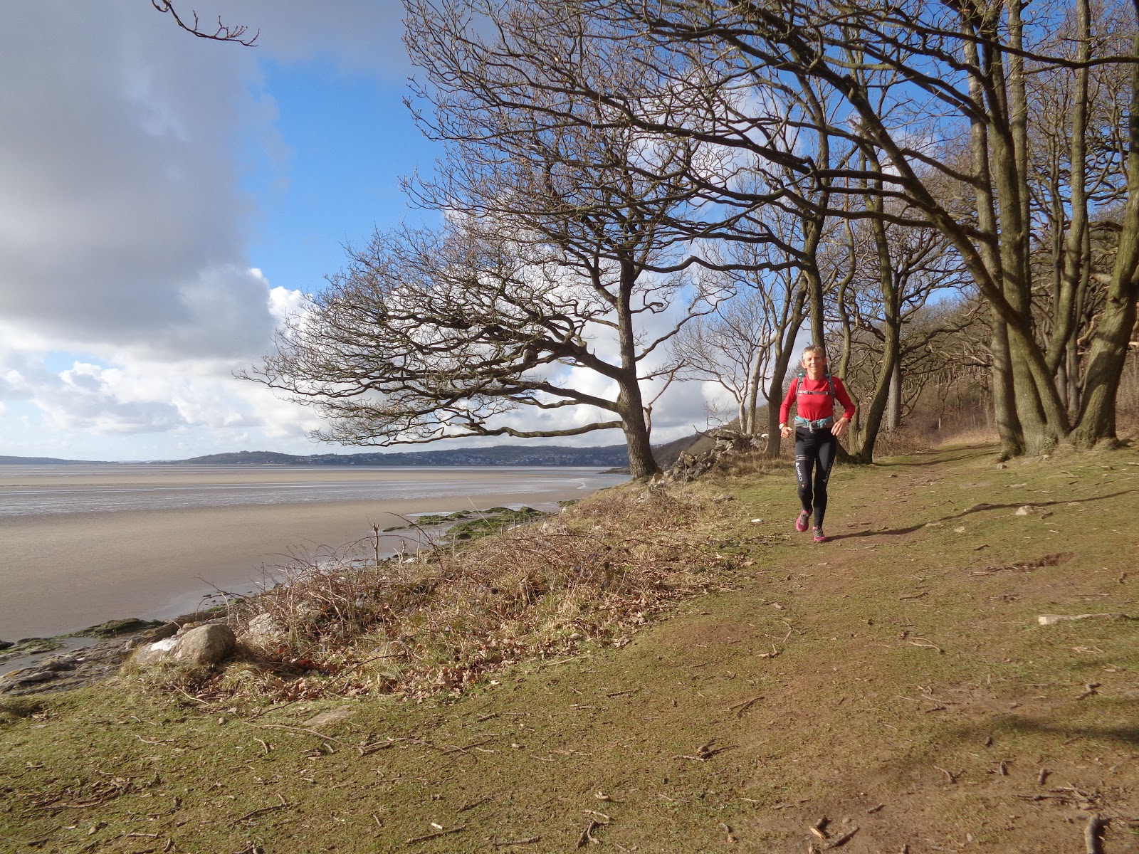
We (Bob and I) set off at the same time but had agreed we would not try to run together. The first section was easy; out of the car park, past the control gates and on level paths along the lakeside and into the woods.

Before long I passed the first campsite at Brod Bay (about 5.5km in) and people bleary eyed making breakfast. I stopped for a photo and to say good morning. The track was now wide and almost flat and I had to force myself not to get carried away.

 Before long the path began to climb but it was nicely graded and I was still running almost all of it. Just as I started to wish for a view and not forest I was rewarded. The path  changed and cut below a huge overhanging cliff complete with wooden steps, walkways etc. DOC (Dept of Conservation) build lots like this especially on the Great Walks both to make it easier and also to protect the terrain and vegetation. It is controversial like in the UK but it was a good way to rapidly gain some height.
 Having climbed round and up through this cliffy section suddenly I was out in the open with vegetation more reminiscent of the Pennine Moors without the bog but no easier to run across. It was already very sunny and hot.

The open terrain meant I now had a view almost to the Luxmore Hut. I met my first 4 walkers on their way down having spent the night in the hut.

Kiwis seem to do this a great deal; spend 3 days doing a one day walk with two overnights and very short days.

I was now getting my first real views of the bigger mountains in Fiordland. The path continued to be easy and although it was mostly climbing the angle was easy. Arriving at the hut  after about 14km I found myself surrounded by teenagers from Sydney doing their gold DoE. We chatted and they took a photo for me. They thought I was mad to be running it all in a day but then I didn't have huge sacks like them. I refilled my water bottle, used the loo (NZ has toilets everywhere and almost all have paper) and filled in the hut intentions book in case Bob looked later and wondered how long I had taken.

 I took a detour to visit the nearby caves and said I would catch the kids up later. Fortunately I had a head torch and spent a few minutes down the cave but really I wanted to get on with the route and the views. Back past the now deserted hut and yet another climb.

 I could see the kids up ahead and it spurred me on. We chatted about Sydney where I have two brothers. Turns out they had heard of Preston courtesy of their Economics teacher who supports PNE! Small world.

The path was narrower now but still a good surface and it climbed, swooped and contoured along the open high ridges. This for me was the best bit with such wonderful views and a bit of a breeze. Once past the school group I saw very few people going in either direction.

I stopped for numerous photos as I followed this section past the two smaller shelters and the views opened up to the north and west as well as the east.

Forest Burn is just an emergency shelter but a couple were cooking breakfast there.

After Hanging Valley Shelter (about 23km) I was buzzed by a tiny plane and then the path turned sharply south. I ran along this ridge with ever changing views. The path changed too with wooden boards and then steps that I guess were to prevent erosion.


The rocky lump at the southernmost point was a lookout with great views into the Iris Burn valley and across to Mount Tinlsey and then the path turned west again before plummeting down and into forest.

I did not know it at the time but the best bits of the routes were now over. (I guess if I had studied the profile and maps more carefully this would have been obvious). The path down was quite steep and had been washed out in places. It was still perfectly safe but there had been some landslides of mud and trees. I passed a small number of people flogging up and they were envious of my small load. The path wiggled around a fair bit here but I find it rather disorientating in the forest and just kept following the orange markers down, along, over bridges, into side valleys etc.

 I was starting to wonder just when I would get to Iris Burn hut when suddenly there was a small sign. By now I was out of water and running flat out but it still took me the 15 minutes on the sign so heaven help walkers. The Iris Burn Hut hut was not quite half way although possibly more than half way in terms of effort. I quickly wrote in the intentions book as a safety measure although down here on a big path and in the valley I really didn't think there was much danger. The hut was deserted except for the warden as the overnighters had already left and the big school group was some way behind me. Pete the warden broke off from his decorating to chat but the sand-flies were such a pain that after refilling my water bottle and eating two sandwiches I pushed on.

It was now the middle of the day and the afternoon was scorching. I wished I had less clothing and an extra water bottle. The next 30km were much easier in terms of climb but seemed harder mentally. At first the path weaved through forest and I concentrated on spotting and catching walkers who had left that morning. Then there was a more grassy open section where there had been a massive landslip some years ago.

Then it was back to forest with a big path that swooped in loops and climbed over many small spurs and wiggled around to find bridging points for the many side streams. Some bridges had been washed away by floods and the trees the water brought down. Some of the climbs up and over spurs were where the path had already been rerouted away from eroded river cliffs. I was still catching people who had left the hut that morning and eventually a few coming the other way too. It was good to stop and have a quick chat. The main river seemed to disappear for a while and I realised I had run out of water. The last few kilometers to the Moturau Hut were a struggle.

I took some time there and refilled my bottle several times as well as eating most of the remaining food. Again I filled in the book just in case and so that Bob would know when I had gone through. It was a beautiful spot overlooking the lake and I was jealous of the two Brits I chatted with as they were staying the night and had just been for a cooling swim.

 Still, less than 16km to go now.  Fearful of seizing up I set off again first along the lake and then into a beautiful beech forest. A wooden walkway over a fragile wetland provided some variety for a short time. Again the profile looked flat but there were some deceptive little climbs and then a diversion where the river cliff had collapsed. By now I was tired even if I was still enjoying my day out. I passed families on short walks and realised I must be not too far from a road of some sort.

It wasn't long before I arrived at the suspension bridge (or swing bridge in kiwi speak) that leads to Rainbow Reach car park. The last 6km had taken its toll. If I was tired I suspected Bob would be feeling the same way or worse. I did some mental maths and using old race times tried to work out where he would be and how far behind me. I came up with a plan to save him and spur me on. I would race the last 10km to the car and then move it to Rainbow Reach. I hoped I had time. After the bridge the path follows the bank of the Waiau river although it is not always visible.

It must have been scorching because I was grateful for the shade. I plodded on and kept hoping and hoping to see the control gates that would mean the car was close by. Suddenly the river looked huge but flatter.

the path changed and the trees thinned a bit. Yes! I could see a man made structure. It spurred me on and in about 8 hours 30 I reached the car. I was happy to have stayed under half the DOC time given how many stops I had taken for views and photos. What a great day.

 I grabbed the water that I desperately needed and ate some fruit but did not dare to linger. The drive was fine despite a dirt road and I arrived back at the bridge in plenty of time. I was sure I could not have missed Bob but I did start to worry. Eventually I asked a girl walking back the way we had come to keep an eye out for him and tell him that I had moved.

A couple of hours later and he appeared. Tired and happy with his 50km day out but pleased not to have to do the next 10km. At least it wasn't far back to the posh campsite and a shower.